Identifying Productive Sandbanks and Drop-offs
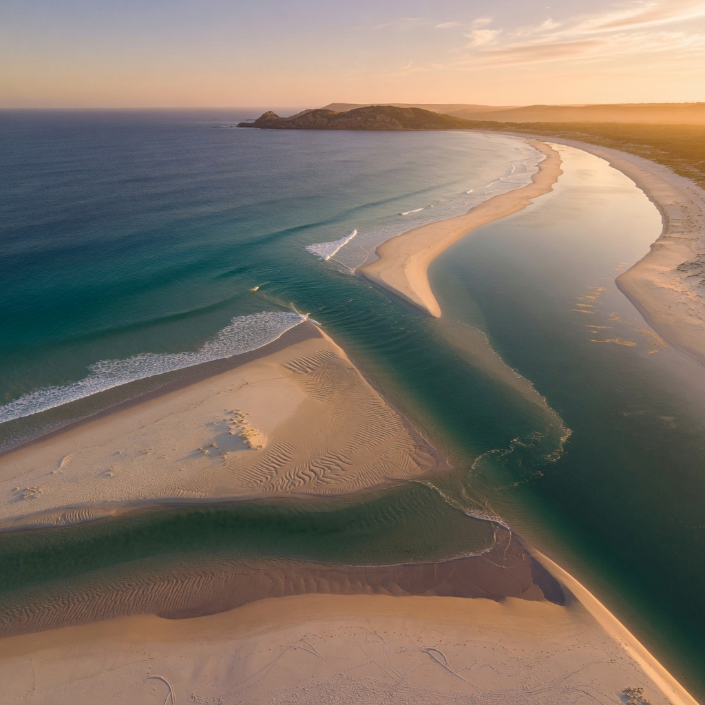
Why Sand Structure Decides Your Session
Sand looks featureless from the car park, but underwater it is a shifting landscape of banks, gutters, holes and drop-offs. Fish use these features the same way they use rocks and reef: as travel lanes, ambush points and places where food is concentrated by moving water. Around Sydney, from the long open stretches north of the Harbour to the sheltered sand flats inside Botany Bay and Pittwater, learning to read this structure is the single biggest step from casting hopefully to casting with purpose.
A sandbank is simply a raised area of sand. A drop-off is the edge where that bank falls away into deeper water. Bait gets pushed over the shallow bank by swell or tide, then tumbles into the deeper edge where predators are waiting with the current in their favour. Find that edge and you have found the feeding zone.
Reading the Beach Before You Wet a Line
Arrive early and spend ten minutes watching rather than rigging. The clues are visible from the dune line, and they are clearest on a dropping or low tide when banks are exposed.
- Colour change: pale green or milky water sits over shallow sand; darker blue or brown-green marks a hole, gutter or drop-off.
- Broken versus unbroken waves: swell breaks on banks and rolls through unbroken over deeper gutters. A gap in the white water is often a channel.
- Foam movement: foam draining sideways along the beach then out through one point shows you where the rip and its exit gutter sit.
- Surface texture: a slick, oily-looking lane between broken water usually means depth and outflow.
- Wet sand shape at low tide: low humps of firmer sand and pooled water at the base of the beach map the gutters that fill on the rising tide.
Beach Gutters and How to Fish Them
The most productive beach gutters are the ones with an obvious entry from deep water and a scour hole at one end. Cast into the deeper trough and let baits or lures sit or drift near the edge rather than winding them across the shallow bank. Whiting and bream work the shallow lip on a rising tide; tailor, salmon and jewfish patrol the drop-off edge, most reliably in the low-light windows at dawn, dusk and either side of a tide change.
Estuary Flats, Channel Edges and Yabby Banks
Inside the estuaries the same rules apply at a smaller scale. Look for the crease where a sand flat drops into the main channel, often marked by a line of weed, a change in ripple pattern, or a row of moored boats sitting in deeper water. Yabby banks and worm beds show as pocked, dimpled sand at low tide — mark them with a landmark on shore, because on the flood tide fish will move straight onto that food source. Drains and small feeder creeks that empty across a bank create miniature rips worth a few casts on the last two hours of the ebb.
Inshore and Offshore: Finding Edges from the Boat
From a boat, sand structure is easier to find and easier to overlook. Run your sounder along an edge rather than straight out, and watch for the sudden change from clean hard sand to a rubble or weed fringe — that transition line holds more fish than the middle of a featureless flat. Note the depth at which the drop-off sits, then look for the same depth contour along the coast; productive edges tend to repeat. Save waypoints on the down-current side of each bank, because that is where bait accumulates once the tide gets moving.
Tide, Swell and Wind: Timing the Structure
Structure without water movement is just scenery. Use tide charts to plan around the two hours either side of a change, when current bends around banks and pushes bait off the edges. A moderate swell of around one to one and a half metres cleans out beach gutters and stirs food without making the wash unfishable; very large swell can flatten and refill a gutter overnight, so re-read the beach after every big blow. Offshore winds hold the surface tidy and let you see colour changes clearly, while onshore winds add chop and colour that can help on bright days but hide the structure. Moon phase matters mainly through tidal range — bigger spring tides around new and full moon move more water across banks and often sharpen the bite window.
Build Your Own Structure Map
- Visit your closest beach or flat on the lowest tide of the month and photograph or sketch the banks from a headland or dune.
- Record the tide state, swell height and wind direction each time you fish, along with what you caught and where.
- Return on a high tide and fish the gutters you mapped, casting to the deeper edge.
- Re-check after any large swell event, heavy rain or spring tide series, since sand moves constantly.
Over a season this simple log becomes more valuable than any general advice, because it is specific to your stretch of coast. For more local condition guides, tide and moon information, get in touch with Tide Fishing on +61292658222 or at [email protected] during Mon–Fri: 09:00 – 17:00 (AEST). Always check current forecasts and warnings before heading out, and never turn your back on the sea when fishing rock or beach edges around Sydney.

Navigation
See also
FAQ